


la Richardais le minihic

vienne14400
User
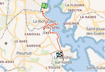

Length
10.8 km

Max alt
45 m

Uphill gradient
144 m
Km-Effort
12.8 km

Min alt
3 m

Downhill gradient
148 m
Boucle
No
Creation date :
2020-08-13 08:59:29.988
Updated on :
2020-08-13 13:02:45.288
4h02
Difficulty : Very easy

FREE GPS app for hiking
 SityTrail
IGN / Geographical institutes
SityTrail Plus
The world is yours!
About
Trail Walking of 10.8 km to be discovered at Brittany, Ille-et-Vilaine, La Richardais. This trail is proposed by vienne14400.
Positioning
Country:
France
Region :
Brittany
Department/Province :
Ille-et-Vilaine
Municipality :
La Richardais
Location:
Unknown
Start:(Dec)
Start:(UTM)
570806 ; 5384999 (30U) N.
Comments